We've tried to ensure the information displayed here is as accurate as possible. Should there be any inaccuracies, we would be grateful if you could let us know at info@ipohworld.org . All images and content are copyright.
(Please click on the thumbnail for a bigger image.)
View Of Ipoh Town Across The Padang To Hale Street
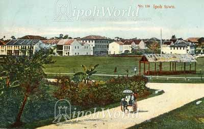
This divided back, tinted postcard was sent internally in Germany and carries a German stamp. It shows a rickshaw puller with passenger moving away from the Padang on Douglas Road, in an area now taken up by St Michael's Institution. In the background the Padang and the Hale Street shophouses, some still under construction, can be seen. It is believed that this photograph was taken from the site which later became St John's Church grounds.
The Beginning of the Ipoh Padang
In 1897, two citizens, C.G. Ogivile, a prominent miner and G.J. Penny, manager of the Strait Trading Company Batu Gajah, raised the funds for the acquisition of a public recreational ground in Ipoh to commemorate the Queen's Diamond jubilee.
The Chinese community supported the proposal and contributed over $43 000. The Padang Ipoh was born.
Dating this Card.
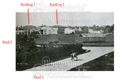
In an effort to be precise about the date of this card Ipoh Remembered produced the above images 3 and 4 in high resolution to establish which buildings were actually represented here.
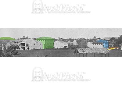
The first clue was the two three-storey buildings with their roofs showing abobe the Hale Street houses. They are marked as Building 1 and Building 2 on the third, black and white image and coloured Greem in the last image. Also, the first Chartered Bank Building can be seen (coloured Blue) towards the right hand end. This building dates between 1902 and 1924 when the bank commissioned their ne building.
Ipoh Remembered now takes up the story:
In the HR image ipohWorld sent, I was able to see that the building in the centre that I had marked in green located where the Chartered Bank is now located, was in fact the previous (first) occupant of that lot. There is at least one photograph of the front of this "green building" (see database item 1803):
And if you take a close look at that building, you'll see that this building looks very much like the building at the other end of the block (Building 1, the one that's often called the De Silva building).
In fact, the two buildings were identical twins, constructed in 1904 as "book-ends" for that part of Station Road, and smaller shop-houses were built in between.
This twin (21-23 Station Road) was occupied for a while by Aylesbury & Nutter (&/or Garland &/or Pearse); while the other twin (43-45 Station Road) was occupied for even longer by McAlister.
These firms had a complicated history. On the one hand there was Aylesbury & Garland; and on the other hand there was Nutter & Pearse. but, for now, suffice it to say that collectively the two firms at various times had premises in Tapah, Taiping, Ipoh, Tanjong Malim, and Telok Anson. Eventually the firms merged to form Aylesbury & Nutter, which then, in Ipoh, operated simultaneously out of two separate premises, including this one on Station Road.
43-45 De Silva) is still standing, but 21-23 was torn down by the Chartered Bank in the mid-'20s to make way for their new premises. The Bank tore down the building because it was too small for their plans; they also tore down the two shop-houses immediately to it.
To return to the original question:
Buildings 1 and 2 are now identified: they were built in 1904. And Road 2 was built in 1905.
So, assuming that the photograph was taken between 1905 and 1911 (the post-mark on the post-card), then Road 1 was still called Kuala Kangsar Road and Road 2 adjacent was likely called Clayton Road (it was first called Clayton Street, but only for a very short time).
Finally, the post-card is presented in Twentieth Century Impressions — which narrows down the date even further: it must have been taken between 1905 (construction of Clayton Road) and 1907 (completion of book manuscript).
To see the Database Item 1803, click here.
To read more about St Michael’s Institution, click here.
To read a brief history of the Rickshaw, click here.