We've tried to ensure the information displayed here is as accurate as possible. Should there be any inaccuracies, we would be grateful if you could let us know at info@ipohworld.org . All images and content are copyright.
(Please click on the thumbnail for a bigger image.)
Aerial View Of Ipoh Town
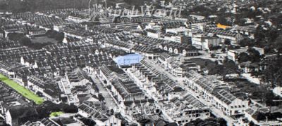
We thank Ipoh Remembered for sharing this picture with us. The green, blue and orange highlighted sections are Cowan Street, Ruby Cinema and the former 'Food Control' office (now Public Bank). With regards to the 'orange' building, Ipoh Remembered adds that it was built in the late ’30s; and later in 1991 it was taken over by Public Bank, who installed a new aluminium façade. At the top of the photo (centre) a tiny arc of the Kinta can be seen, winding its way downstream and out of the town.
When this was shared on the blog, Ignatius Chiew told us:
Photo found on page 13 of “IPOH: THE TOWN THAT TIN BUILT” published and edited for Ipoh Municipal Council by Phoenix Communications Limited and printed by The Straits Press (Malaya) Limited, May 31, 1962, when Ipoh received Municipality status.
The caption says “Ipoh as it is today, taken over New Town, with Old Town in the middle distance on the right and Kinta Valley beyond”.
The top of the original photo was cropped resulting in the above. The cropped part showed the Kinta Valley and hills.
[Ignatius also adds] "....from the thoughts shared by various people, I can say that if you follow the front of Ruby Cinema to the right, it will be Cathay and Lido Cinemas."