We've tried to ensure the information displayed here is as accurate as possible. Should there be any inaccuracies, we would be grateful if you could let us know at info@ipohworld.org . All images and content are copyright.
(Please click on the thumbnail for a bigger image.)
The 'New Look' Sungai Kinta After Flood Mitigation & Deviation
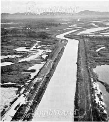
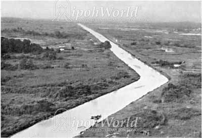
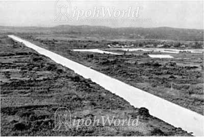
This photograph shows the 'new look' of Sungai Kinta after the flood mitigation and deviation works.
Sungai Kinta once the life-line of Kinta, was badly damaged by the mining and agricultural sectors in Kinta Valley. The deterioration of the river due to sedimentation, caused the 'record flood' in Ipoh on 24 September 1919. As the pressure from the public was mounting, an extensive flood scheme was immediately drawn up by the state engineer. The plan was to straighten the sharp bends in the Kinta River and divert the River Choh so that it would flow into the Pinji River instead of directly flowing into the Kinta River above Ipoh.
The plan was shelved during the First Slump of 1919-1922. In 1924 a dam was erected above Pulai and silt traps were provided, but these soon filled up or were broken through. In 1926 Ipoh suffered the worst-ever flood and the following year the Ipoh Flood Mitigation Scheme was inaugurated. This was an important step as making Ipoh flood-free was a pre-requisite of the town becoming the capital of Perak.
The scheme was exercised in three phases (1929-1930) - construction of a channel passing through Ipoh town from Anderson Road to Kuala Pari, diversion of Sungai Choh and clearing of the Kinta River and its main tributaries. However, the large silt trap of 1.5 million cubic yards at the bed of river below Kuala Pari was unable to control the silt effectively and Ipoh’s floods continued, although they were not so serious.
Then the Perak government and five major mining companies set up a corporation to divert 21 miles of river in exchange for new mining rights of 1,300 acres. The five companies were Pengkalen Ltd., Malayan Tin Dredging Ltd., Southern Kinta Consolidated Ltd. (Kinta Section), Southern Malayan Tin Dredging Ltd. and Southern Kinta Consolidated Ltd. (Penawat Section). The plans alone took 10 years in making, while the war brought another postponement. By 1950s, the project was extended to encompass the straightening of 38 miles of river, from the vicinity of Ipoh to Kuala Chenderiang.
The Kinta River was remade into a 22 miles long canal, seven feet deep, with a 120 foot wide bottom, flanked by spoil banks six feet high and ten feet wide; both berms and banks were grassed. Five weirs were installed at selected intervals to brake the flow of water down to a total drop of 27 feet. In this project, the mining companies undertaking the deviation works had to connect the tributaries, divert the roads and rebuild all the bridges.
Much more information on this topic is available in the Kinta Valley book.
To read more about the book ‘Kinta Valley’, click here.